Processionsvägen vid
Rösaring
- nya synpunkter
(moon97.htm)
UKF:s Startsida
Rapporter Rösaring
Ämnesområden
Se också Börje Sandéns försök till tolkning
av processionsvägens användning i artikeln
Fifty years with the Cult Site of Rösaring
i Viking Heritage Magazine nr 2002:3
The Sun and the Rösaring Ceremonial Road
Artikeln är en bearbetning och utökning (febr
1997) av den rapport som presenterades
vid en arkeologikongress i Riga hösten 1996. Språket
är engelska.
Artikeln diskuterar möjliga astronomiska aspekter
i samband med processionsvägen:
- solen - månen - Vintergatan - regnbågen
- norrskenet.
En nyhet i jämförelse med den första rapporten
är några synpunkter på Frös-kulten
Läs en kortfattad sammanfattning
på svenska av Curt Roslunds föredrag 97-04-22
(97-05-31)
 The
Sun and the Rösaring Ceremonial Road The
Sun and the Rösaring Ceremonial Road
Emilia Pásztor
Dunaserr Human Institute DUNAÚJVÁROS Hungary
Curt Roslund
Department of Astronomy Gothenburg University GOTHENBURG Sweden
Britt-Mari Näsström
Department of Religious Studies Gothenburg University GOTHENBURG Sweden
Heather Robertson
Department of Architectural Forms The Royal Institute of Technology
STOCKHOLM Sweden
.
|
| Abstract - A well-built roadway from the early
Viking Age at the Rösaring archaeological site in central Sweden connects
an imposing mound with a rectangular stone arrangement that could have
been the base of a building. It is generally assumed that the roadway was
used for processions setting out from the building for ceremonies at the
mound to the south. This paper examines the north-south orientation of
the road in relation to its surroundings, the sun and the moon, the rainbow
and the Milky Way. The play of sunlight over the road at noon was found
to be particularly spectacular at midwinter and well-suited for enhancing
the performance of rites taking place at the barrow, possibly in connection
with the cult of the Old Norse fertility god Freyr.
The Rösaring
roadway is the only known example of its kind in Scandinavia. It is located
35 kms northwest of Stockholm, and forms part of the wellknown Rösaring
archaeological site in the municipality of Upplands-Bro on the northern
shore of Lake Mälaren. The site occupies a commanding position at
the high southern end of a glacial ridge, the flat top of which is one
kilometre long and rises forty metres above the surroundings. To the south
of the site, there is a particularly steep descent, and a magnificent view
over Lake Mälaren. Although the name Rösaring alludes to a sixteen
metre wide labyrinth laid out in the form of sixteen stone rings, the site
is dominated by a two and a half metre high mound. It was discovered as
recently as 1979 that this mound was the starting point for a roadway that
ran on level ground very nearly in a straight line almost due north for
540 metres. |

Road construction
Excavations of sections through the road have revealed a surprisingly
high standard of construction. The roadway is about 3.5 metre wide and
contained within two unbroken rows of kerbstones. It is bounded on its
west side by a ditch from which sand was taken to build the road embankment
and on its east side by a parallel line of regularly spaced shallow depressions
in the ground of unknown purpose. The surface of the road had been sealed
with a top-layer of clay. A construction time of early Viking Age has been
derived from a radiocarbon dated sample taken from below the road bank
at its south end. The care with which it was planned and engineered is
an indication that the road was built for recurrent use and that it held
an important function.
The Rösaring road is unique. Viking roads were mostly tracks that
were shifted sideways when the surface turf was worn through. Only occasionally,
especially when they had to overcome marshy tracts, did the Vikings display
much road building skill. The 800 metre long wooden bridge constructed
around AD 980 at Ravning 13 kms west of Vejle in present-day Denmark is
a good example of their competence. On the dry and firm ground surface
of coarse sand on top of the Rösaring ridge, there would have been
little practical need for a road embankment. Also, it is difficult to imagine
a road on an isolated ridge with steep hillsides to be a link in an important
everyday communication and transportation network.
Ceremonial road
An alternative function for the road might have been one for ritual
use. The roadway terminates to the north in a rectangular stone arrangement
that could have been the base of a small building, perhaps a mortuary or
a wagon shed, from which processions could have set out for ceremonies
at the mound. The smooth surface of the roadway would have enabled wheeled
vehicles or sledges to move steadily and stately along the road. Although
the mound at its south end has never been subject to excavation, it has
generally been assumed that it contains a burial contemporary with the
construction of the road. Its flattened top would have been ideal as a
podium for persons or cult images in whose honour the processions took
place. It is said that a king had to stand on the burial mound of his ancestors
when he laid claim to the kingdom by right of succession. The mound could
also have served as a platform for sacrificial rites. Sacrifices to the
gods were at times carried out on mounds of important persons.
Several cases are known of finds of vehicles
that might have been used in cult processions and ceremonials. One richly
decorated wagon and four sledges from the early 9th century AD that were
found with the Oseberg ship burial in southern Norway may have taken part
in a procession at the funeral service. Pictures of covered wagons on fragments
of a tapestry recovered from the same burial may refer to such a procession.
Although of Celtic origin from the 1st century
BC, two beautiful wagons that were reconstructed from finds in a peat bog
at Dejbjerg in Denmark, may also have been the sacred vehicles of gods
or goddesses. The Roman historian Tacitus reports from the first century
AD in his great work Germania that the Teutonic fertility goddess
Nerthus travelled in a covered wagon. An analogous story is told in Óláfr
Tryggvason Saga in the Flateyjarbók about the god Freyr
who was taken in a wagon on annual visits to farms in Sweden. Mention should
also be made of the famous miniature sun-chariot from the Bronze Age found
at Trundholm in Denmark which could have been a model of a larger vehicle
used in sun-cult processions.
The custom of carrying a god or goddess in
a wagon or on a litter in order to increase the yield of the coming harvest
survived into Christian times in certain parts of Sweden. Around Uppsala,
the heathen deities were replaced by Saint Eric whose relics were carried
in procession on May 18th when the crop was expected to set ears.
Upp
|
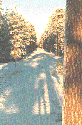
Midwinter 1995-12-22 at 12.13
|
Astronomical orientation
It would have been natural enough for the roadway to be built parallel
with the crest of the ridge but it deviates by five degrees. Had its north
end been moved about fifty metres further east, the road could easily have
been extended for another hundred metres. This deviation could be explained
as an attempt to align the road with the astronomical important north-south
direction.
Celestial objects, including the sun and the moon, rise in the east
and set in the west, reaching their highest altitude in the sky on the
south meridian. In order to establish the relation of the roadway with
this fundamental line, the orientation of the road was measured with a
theodolite using the sun as a reference source. Although the road is not
completely straight, a mean azimuth of 4°08' - 184°08' was obtained
in close agreement with earlier surveying work. Seen from its northern
end, the road points in the direction 4°08' west of due south, which
means that it takes the sun eleven to eighteen minutes, depending on the
season of the year, to arrive over the central line of the road after local
midday, a time lag of little consequence for most applications. |
Days are short in winter at this northerly latitude. At winter solstice,
the sun climbs to a maximum altitude of only seven degrees on the south
meridian. The sun then almost touches the tree tops at the barrow as seen
from the north end of the road, crowning the dark silhouette of the burial
mound with a bright halo of light.
The well-proven skill of the norsemen in navigating the North Atlantic
hints at a considerable understanding of astronomy which they could have
used in setting out the roadway in a north-south direction. Graves in the
form of ship-settings from the same era also show a preference for this
orientation.
Play of sunlight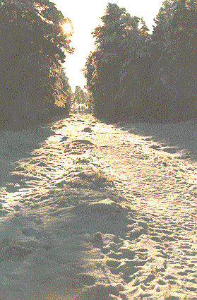
The ridge is today covered with a forest of tall pine trees and sparse
undergrowth. Pollen counts taken from layers supposedly connected with
the roadbuilding reveal that similar plant-species were present then as
now. Today, with the roadway at the bottom of an approximately sixteen
metre deep and ten metre narrow trough through the wood, a dramatic play
of light and shadows takes place when the sun passes over it in winter
when the sun stands low in the south.
At midwinter, the road lies in deep shadow until the first sunbeam reaches
the west side of the road, lighting up the whole length of the roadway
just a quarter of an hour before the sun passes overhead. The grove then
once again returns to darkness half an hour later when the last gleam of
sunlight leaves the east side of the road. The whole breadth of the road
is flooded by sunlight for only fifteen minutes, or approximately the time
it would take for a slowly moving procession to travel the entire length
of the road. The effect is most impressive as seen from the north end of
the road, especially when the low angle of incident sunlight causes sparkling
reflections in a snow cover. As seen from the mound, an approaching procession
on the road would at the same time have been immersed in a golden lustre
by the low-standing sun, creating long shadows which would flicker and
dance on the ground with the movements of the participants, intensifying
the mystic and cryptic nature of the rituals.
The light and shadow show is predictable and dependable. It takes place
shortly after noon on every winter day, weather permitting. In Scandinavia
a fair number of days with sunshine can be expected in winter when high
pressure systems often prevail for long periods of time.
Light and shadow effects
The complex interplay of light and shadow has long fascinated artists
and architects. The medieval cathedral builders sought to create space
that would spring to life with light to heighten the spiritual experience
of the church goers. For contemporary artists, the interaction of sunlight
with the surrounding landscape is a continuous source of inspiration. Nancy
Holt has incorporated a light and shadow arrangement into her design of
Dark
Star Park in Rosslyn, Virginia and of the Sky Mound project
in New Jersey. James Turrell is making use of changes in the sky and atmosphere
to highlight the visual sensation of landscape features in his monumental
Roden
Crater project in the Painted Desert in Arizona and in Sky Garden
on the shore of Lough Abisdealy in West Cork, Ireland.
From Neolithic times, we know a number of structures on the British
Isles that could have been used for processions connected with observance
of celestial events. Best known is the Stonehenge Avenue that leads out
of the enclosure in a straight line for 520 metres in the direction of
the summer solstice sunrise. It may have been built to symbolize the pathway
the sun enters the sacred stone ring on this occasion or to provide a ceremonial
approach for worshippers to the sanctuary.
The Dorset Cursus is another Neolithic structure for which one has suggested
a sacred way for processions making visits to freestanding long barrows
along its route. One long barrow is actually enclosed within the banks
of the cursus. Some of the long barrows stand out as prominent skyline
objects that undergo visual changes during the course of the day, making
the cursus an integral part of nature. In addition, sections of the 10.5
km long cursus seem to be aligned on the midwinter sunset. Penny and Wood
have proposed several lunar sightlines along the cursus. |
Upp

|
|
A few of about 100 round depressions, function unknown. Here
with remaining snow. Comment Börje Sandén.
|
|
Summer full moon
The full moon on summer nights is responsible for similar light and
shadow effects to those of the sun, although less striking on account of
the moon's lower luminance. The moon as a nocturnal object has obvious
associations with death, but it is an unlikely reason for ceremonies as
the full moon passes over the roadway in the middle of the night, although
it should be remembered that summer nights at this latitude never get really
dark. Another difficulty with the moon is that its somewhat irregular movement
makes it hard to know in advance on what date it will be full without recourse
to a reliable calendar. On the other hand, a torch-bearing procession slowly
advancing in the summer night towards the golden disc of the full moon
above the mound in the light of open fires in the shallow depressions that
line the road would have made a spectacular sight. |
There is also one remarkable feature of the moon's movement that should
be mentioned. Every eighteenth or nineteenth year, the full moon's path
in summer will take it down to merely one degree above the horizon in the
direction of the road. If there were no vegetation on the burial mound
or beyond it to obstruct the view, the full disc of the moon would then
be standing right on the crest of the mound as seen from the road some
fifty metres from it. When coming closer, the moon's disc would gradually
disappear out of sight behind the barrow until one climbed out of the narrow
confines of darkness up onto the top of the mound with its vast expanse
of moonlit vista across the water of Lake Mälaren below the ridge.
Bridge of colours
A special effect of sunlight is the rainbow. It appears when sunlight
falls on rain drops. It lies on a circle that has an angular radius of
42 degrees, centred at the antisolar point, which is a point in space directly
opposite the sun as seen by the observer. Each colour forms a bow of slightly
different size, resulting in the familiar continuum of colours.
The rainbow is high in the sky when the sun is near the horizon on the
opposite side of the sky. It then forms a semicircle with its both ends
rising straight up from the ground. The right leg of such a rainbow can
be seen from the road to hover over the barrow when the sun sets around
midsummer. This is a stunning event with possible strong symbolic implications,
as the rainbow near the ground often appears much brighter than the rest
of the bow, when the sun stands low in the sky. It glows with an eerie
red lustre due to the scattering of the shorter light waves along the long
path through the earth's atmosphere. The occurrence of this particular
rainbow is of course both infrequent and unpredictable, but it is not unusual
in this part of Sweden that storms develop in summer afternoons and that
the sky clears up shortly before sunset.
The rainbow figures repeatedly in myth and legend. A well-known folk-tale
promises that a bowl full of gold is to be found at the foot of every rainbow.
In the Old Norse mythology, the rainbow was the bridge Bifrost built by
the gods to join earth with heaven. At Rösaring, the rainbow might
have been seen as a link between the earthly grave at the end of the road
and the heavenly resting-place of a great hero.
Upp
Bridge of light
Although it is explicitly stated in Snorri Sturluson's Edda that Bifrost
is the rainbow, claims have been made that the bridge leading from earth
to the heavens was a metaphor for the northern light, or alternatively,
that it represented the Milky Way. However, based on modern research on
changes in solar activity and the strength of the geomagnetic field, Brekke
and Egeland have come to the conclusion that the northern light would have
been a rare phenomenon when the Icelandic Sagas were written and an unlikely
explanation for the name Bifrost.
The Milky Way, on the other hand, surely appears as a bridge of diffuse
light that spans the night sky from one point on the horizon to its opposite
side. Before the glow from city lights practically obliterated the stars,
the Milky Way was an eye-catching feature in the dark winter nights of
the North, especially when it was seen reflected in the snow on open ground.
The Milky Way moves with the stars. It passed through the zenith above
Rösaring in the Viking Age about two hours before midnight at the
time of the winter solstice. For the next two to three hours, the Milky
Way crossed the south meridian appearing as a white cloud of light in the
clearing above the barrow at the south end of the ceremonial road. The
effect was heightened by the simultaneous passage of the prominent pattern
of stars in the constellation Orion and the brightest star in the sky,
Sirius.
It is interesting to note that Orion in Sweden in Medieval times was
named after Frigg, Odin's wife, and called Frigg's spinning wheel or spindle.
Now there is some evidence that Frigg and Freyja originally were a single
goddess. Freyja was the sister of Freyr who with Odin and Thor was worshipped
in the famous heathen temple at Old Uppsala. It is then somewhat strange
that the three bright stars that make up Orion's belt were not instead
seen as representing this triad of popular gods, especially as the stars
would have formed a conspicous asterism in the evening sky after sunset
around the vernal equinox. This is when, according to Adam of Bremen, the
offensive sacrifices of humans and animals took place in the grove outside
the temple.
Upp

Freyr
Bild hämtad ur "Klenoder ur äldre svensk historia",
Statens historiska museum,
med många intressanta bilder och beskrivningar
Finns i bokshopen.
|
|
Cult of Freyr
The mound at the south end of the roadway is part of a large funerary
complex of cairns and smaller stone settings which have been assumed to
be from the Bronze Age. There is also a stone labyrinth for which no dating
is possible, but its location close to the cemetery points to a probable
relation. Kraft has brought forth evidence for a construction date for
the oldest labyrinths in Sweden to the early Iron Age or possibly even
the Bronze Age. He envisages the labyrinths as arenas for fertility rites
in spring, that imitated the sky god forcing his way through the winding
path of the maze to liberate the vegetation goddess in the centre. The
Rösaring labyrinth would have been an appropriate place for enacting
a union of the sun with the earth, situated as it is close to the sky on
top of the ridge with a breathtaking view of the fertile land below.
Rösaring as a cult place may have continued in use for several
centuries well into the Viking Age when Freyr had become the prominent
god of fertility and prosperity. From the distribution of place names containing
Freyr's name, his cult in Sweden seems to have been centred around Lake
Mälaren. As mentioned earlier, he was worshipped at Old Uppsala only
45 kms north of Rösaring. By a strange coincidence, a straight line
joining Rösaring with Old Uppsala would point six degrees east of
north in close agreement with the four degrees east of north for the direction
of the roadway.
|
The name Freyr literally means the Lord which probably masks his real name.
In the sources, he is described as bright and radiant. Snorri Sturluson
tells us in the part of his Edda which is called Gylfaginning
that Freyr ruled over rain and sunshine. Freyr's impersonation of the sun
is clearly demonstrated in the Edda poem Skírnismál
where he sends his servant Skírnir, meaning the shining one, who
is no other than an incarnation of the god himself, to propose marriage
on Freyr's behalf to the giantess Gerd. A possible interpretation of this
myth is that Skírnir represents the rays of the sun sent to impregnate
the earth.
Freyr's attribute was a boar, Goldbristles, adorned with bristles of
shining gold so bright that they could change night into daylight. At midwinter
in Sweden, when the sun made its lowest round in the sky, a boar was sacrificed
to Freyr and brought on the table at the Yule festival. With a hand placed
on the bristles, men made solemn vows before feasting on the sacrificial
boar. Because of his kinship with the elves, who were believed to dwell
in burial mounds, Freyr was also associated with the dead in their graves.
He was said to be able to ensure that no snow or frost in winter would
stay on the grave mounds of his patrons. At the Yule festival, the dead
were commemorated when they were imagined to rise from their graves to
take part in the festivities.
| The light and shadow show put on by the low-standing sun over the roadway
at noon at Yuletide would have been befitting to a god of Freyr's character
as a symbol of light and the sun. Also, the sacrificial feasting on Freyr's
boar later at night would have taken place under a canopy of the bright
star clouds of the Milky Way. |
The light and shadow effects here described for the
Rösaring roadway are real and can even today be seen, but we cannot
be sure that they were deliberately thought of by the designers of the
road. However, the exquisite craftmanship of archaeological finds from
this time testifies to the Norsemen's appreciation and search for beauty.
It would be reasonable to assume that these people could also recognize
and respond to the shifting character of the environment during the course
of the day. |
UKF:s Startsida
Rapporter
Rösaring
|